
Navigation strategy is about devising an effective plan to find a target. Walking in a straight line to your target on one leg can be effective when the distances are small and or when the feature you are navigating to is large and obvious, e.g., a prominent loch. It is important to note, however, that there are inherent problems and risks in this:
- Error can arise from both taking a bearing from the map and following it. The further you walk on a compass bearing, the greater the error can be. If, for example, you make a two-degree error in taking a bearing from the map, and then make another two-degree error in following it, over a distance of 800m, you will miss your target by 56m. If the corresponding distance is 300m, the error is only 20m.
- Your straight line route may take you diagonally across a slope. Following a bearing diagonally across a slope can lead to errors, as you are naturally pulled down the fall line, taking you off course.
- The further you walk when pacing or timing, the greater the error in gauging distance.
- Walking in a straight line may also take you across hazardous terrain like crags or cliffs.
With poor visibility and or with snow cover obscuring paths and water features, these problems and risks are compounded. For all of these reasons, it is important to break up your route into legs, linking up prominent landscape features along the way.
Devising a navigation strategy involves lots of different skills and techniques, like:
- Aiming off.
- The use of attack points.
- Identifying a clear and not too distant catching feature.
- Identifying point features that are clear in the landscape, things like spurs, summits / small ring contours, cols, and small re-entrants.
- Identifying slope features like prominent breaks in slope and slope aspects.
- Identifying linear landscape features like ridges, breaks in slope, and re-entrants, and streams.
- The effective use of pacing and timing.
- The effective use ofa compass for direction and relocation.
A useful exercise, before formulating a strategy, is to take time to identify all the useful landscape and man-made features in the landscape that will aid navigation. See image below:

Three very useful techniques that can form part of your strategy are aiming off, the use of attack points, and the use of catching features. These are described below.
Aiming off
In circumstances where you want to navigate to a subtle point feature that is a long way off, you can sometimes utilise a linear feature that the point feature is aligned to. The technique involves deliberately navigating to one side of the intended target, then, upon reaching the linear feature, following it along the linear feature to the target. See example below:

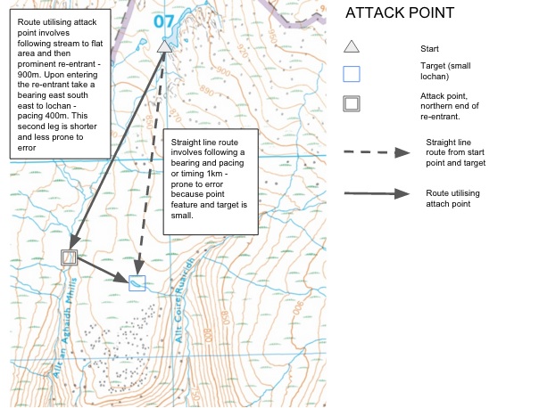
Attack Point
An attack point is an intermediate point between your starting point and your target. It is a point feature that is obvious and identifiable in the landscape and close to your target, from which you can navigate to your target in a straight line in one further leg. Using an attack point that is closer to your target means that you reduce errors arising from compass bearings and pacing, and timing. See image below:
Catching features in navigation strategy
Utilising catching features is very useful and should form part of your navigation strategy. A catching feature is a man-made or landscape feature that lies beyond your target and would tell you, should you reach it, that you have missed the target and gone too far. Catching features should be clear and obvious in the landscape – for example, a break in slope – and be close to your target.
Catching features can be used in conjunction with attack points to aid navigation. Sometimes you may be able to choose from several attack points. The best strategy is to choose an attack point that has a catching feature – that is clear – and close to the target. See image below.

Formulating a Strategy
To formulate a navigation strategy, consider the following steps:
- Make sure you can identify your starting point accurately on the map – it should be a point feature that is on the map and in the landscape.
- Identify all the man-made and landscape features that could be used as:
- Collecting features – consider breaks in slope, slope aspect, water features, linear features, area features, point features;
- Attack points – these should be clear in the landscape and close to your target.
- Catching features – these should be clear in the landscape and close to your target.
- Avoid a route that goes diagonally across a slope, particularly downhill, because of errors arising from being drawn down the fall line.
- Choose a route that avoids hazards
- If targets are small and subtle, consider using the aiming off technique.
Consider the following example:

There may be a number of strategies that will work in finding your target, each with different advantages and disadvantages. The key to your success is.
- Contour interpretation – the ability to identify landscape features on the map and in the landscape that you can utilise as collecting features, attack points, and catching features; and,
- The application of navigation skills like pacing, timin,g and compass bearings.
Micro-navigation practice in good and bad visibility is an excellent way of developing your ability to come up with and execute effective navigation strategies.
This article forms part of a series about navigation skills:
If you would like to learn navigation skills, why not attend one of our navigation courses, accredited by the National Navigation Award? We run beginner, intermediate, and advanced courses (Bronze, Silver and Gold NNA Courses)