
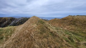
The word Yell means unfruitful land in Old Norse, and when visiting, one’s main impression is of a vast, empty, barren moorland. This is largely because of geology. An ancient metamorphic rock called Moine predominates. Its impermeability and acidity create ideal conditions for moorland plants like heather, sedges, and sphagnum moss, and the formation of deep layers of peat.
Barren landscapes, whether moorland, desert, or arctic tundra, have always been a draw for me. I’ve often daydreamed about a long journey across the island of Yell, or along its long stretches of uninhabited coastline. Earlier this year, when visiting Shetland on tour, I learned of plans for two new, very large wind farms on Yell, so large they’d produce enough energy for 500,000 homes. My heart sank knowing the impact this would have on the wild land of Yell. The news hastened my resolve! If I didn’t explore the island soon, the wild character of the place would be lost.
I set myself the goal of walking around the island, over four to five days, and I’d camp. With guiding keeping me so busy, I figured the best chance for me to do the journey was in November or December. I was content to do it on my own, but I thought I’d reach out to my friends and see if anyone wanted to come:
Is anyone keen to walk around the Isle of Yell? 75 miles of uninhabited coastline and barren peat moorland over four days. It’ll be cold, wet, and windy, with 18 hours of darkness! But there’ll be a good chance of seeing otters!
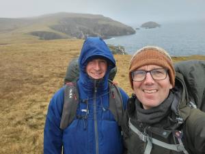
Silence…..! And then, Murray replied….”I’ll come“. Murray, a fellow guide, wildlife photographer, and owner of 20-plus hiking tents, was keen. Murray came with me to Shetland in August 2024, spending a week walking and photographing birds. Whilst he maybe didn’t share my enthusiasm for the austere, ascetic, penitent-like mission of walking through peat hags in the dark, Murray did like a challenge, especially if it involved camping, and also, he was a pal, he’d keep me company and make sure I didn’t fall off anything precipitous!
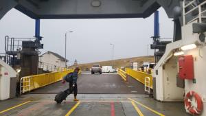
Our travel to Yell went like clockwork, thanks to Shetland’s excellent public transport. First train to Aberdeen, then late evening ferry to Lerwick, arriving 7 am the following morning. Then a seamless connection with a bus to Toft. Lastly, we boarded the Yell ferry for a comfortable 25-minute crossing to Ulsta.
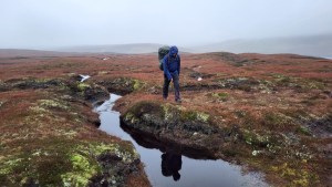
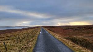
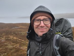
The weather was uninspiring and benign: grey, overcast, light winds, drizzle, and about 9 degrees Celsius. Thankfully, no strong winds were forecast for our hike, so a tent collapse was unlikely, and there was every chance we’d be able to meet our target distance of about 30km a day. We were, however, expecting to be damp most of the time. We stepped off the Yell ferry at 10 a.m., 4 hours and 50 minutes until sunset!
We made rapid progress on day 1. We’d both been training for the trek and felt pretty strong. The morning was marked by prominent landmarks: the tombolo at Sound, the graveyard at North Kirk Geo, the remnants of an Iron Age broch, and the bonny beach at West Sandwick.

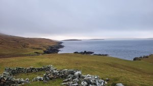
Beyond that lay The Herra, a prominent peninsula bound by the Atlantic in the west and Whalefirth to the east. There are several Herra’s in Shetland. The word is Norse in origin and means a place where justice is administered. More specifically, it relates to an area that pre-dates the judicial reforms of Magnus the Lawmender in 1274.
Before the trip, my Uncle Bruce recommended that I read a book about The Herra, Shetland: Around Whalefirth and The Herra, by Catherine W Williamson. The book recounts local history, folklore, and family stories; for instance, the story of Mass John, a priest, who was considered not learned enough to minister the Reformed faith and, in the 1560s, recused himself, or was exiled, to the remotest corner of The Herra, living out his days in a stone cabin by the cliff edge.
My uncle Bruce reminded me we have ancestors from The Herra. My Dad’s (George Ewen), mother’s, father’s, mother’s father (My great great great Grandad) was from The Herra. His name was Laurence Mann – a fisherman – born in 1812. His birthplace was Graveland in The Herra, and we were going there that afternoon to camp amongst the ruined croft buildings.
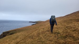
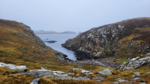
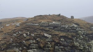
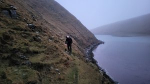
Our journey north of West Sandwick was exciting: no paths; miles of wild coastline; fixating on navigation; discerning shapes through the mist; and puzzling out an efficient line. A notable landscape feature on this stretch, one that we’d come across six times throughout our journey, was a Birrier, a cliff-girt promontory. The word girt has the same root as gird, meaning to enclose or bind with a belt. The name is apt. A Birrer is characterized by a precipitous arete or narrow neck of land, bound by cliffs, that binds, cuts off, and inhibits access to the rest of the promontory, which is generally somewhat flatter, broader, and more habitable. It was evident that many of these Birrier had been put to use as defensive redoubts, with the presence of ditches and walls girding the passage all the more. The Birrer to the north of West Sandwick afforded protection, it is thought, to an early medieval monastic settlement.


By 3 pm the sun had set, it was getting dark. It was drizzly, and we’d stumbled upon an unfriendly bog. Our progress was ponderous and clumsy. Murray and I felt – with some urgency – that we needed to get to camp. Eventually, we reached a fence, marking the end of the boggy common grazing, and ahead, by torchlight, we could see the ruins of Graveland. The tent was erected in 15 min and at last we were undercover, drying off and warming ourselves with cuppa soup. We managed to keep up a pace of 4.5km per hour through the day, covering 25km. Not bad going.
Day 2 was going to be a challenging one. We had to walk a long way inland, to the eastern end of Whalefirth, then walk all the way back to the Atlantic coast on the other side. Then we had a long trek to the far north-west corner of Yell, along an entirely pathless coastline, before heading east to the Gloup, where we’d camp. Murray and I rose at 6:30 am and began our trek at 8 am. Grey weather again, drizzle, overcast, but little wind.
“Where have you taken me, Al?” “You have a bog radar!” said Murray. He wasn’t impressed. “I kinda like this,” I said. “I like the route-finding”. Swear words could be heard. Two hours into our morning’s trek, we were on an expansive peat bog, well inland of the Lee of Vollister. Avoiding the steep ground to the west, we’d decided upon a direct but, it turns out, boggy route to the Daal of Lumbister.
We drudged on, meandering through our labyrinthine bog. Progress, nevertheless, was made, and we eventually descended into the Daal and stopped for lunch.
The Daal is a steep-sided valley, orientated east-west, and Lumbister, a mile or so inland by a loch, was the site of a small community: the one-time parish of Mass John, with houses, grazing, and a mill. The Daal, where it meets the Atlantic, forms a natural harbour, where the folk from Lumbister could launch boats to fish, or ferry in supplies. Catherine W Williamson, in her aforementioned book, recounts the story of a woman called Kirsty who lived in this remote place. It was around 1770 that Kirsty lived with her bedridden mother in Lumbister. She set off one day with a kishie (a basket) to walk to Mid Yell for supplies. Not long after setting off, she noticed the laird’s wife, the Mistress of Dalsetter, on a pony, out for a ride. Unknown to the Laird’s wife, her two young children had followed her, hoping for a ride on the pony. Kirsty reached Mid Yell, procured some fish, and returned home, a round trip of 8 miles. Once home, she realized she had no salt for the fish, so she walked to the Daal to collect some seawater in a keg. Upon reaching the Daal she noticed two small children on the crags. She hurried over to investigate, finding the Laird’s bairns, a boy and a girl, in distress. She set her kishie on the ground, lifted the children inside, and hefted it onto her back. She then walked all the way to Dalsetter, over three miles away. When she reached Dalsetter Haa, Kirsty could hear the inconsolable cries of the Laird’s wife. Search parties had been dispatched, and everyone was desperate for news. Kirsty reunited the children with their mother, and all were overjoyed. In gratitude for Kirsty’s efforts, the Laird granted her free tenancy at Lumbister for the rest of her life. She lived to be 80 years old.
After our lunch, Murray and I headed north, along the coast. The scenery was dramatic with big cliffs, sea stacks, and another cliff-girt promontory redoubt, a fort this time, with an unusual defensive obstacle called a chevaux-de-frise. I imagined early medieval farmers, hastily withdrawing to these natural defenses, evading the sudden and alarming arrival of the Vikings.
Along this stretch, Murray and I started to feel some aches, pains, and blisters that made us wince and slowed our progress a little. “Not far to go now,” I said, “and the last few km are on a path”. Having reached the northwest corner of Yell, just as the sun was setting, I reassured Murray that all we had to do now was journey east and look for the Gloup. Thereafter, a welcome path would lead us to camp.
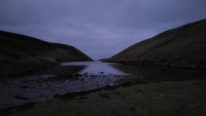
The Gloup is a long inlet of the sea, a voe, running north-south. We found it fine, but my much-looked-forward-to path was a shocker. It started clear enough, but before long, it narrowed to a sheep track, and the slope we were traversing steepened. We pushed on in the hope it would improve. To our alarm, it didn’t. “Where have you taken us, Al? This is awful”, said Murray. “I know, this is desperate, just don’t fall”, I said. Our slope had become much steeper, and a nasty 20m drop to the sea lay below us. It was getting dark, and we were tired. Our choice was to commit to the sheep track or retreat and find another, longer route to camp. Peering into the gloom, we could see some sheep negotiate the treacherous slope. “I think we can get through that,” I said. Slowly, carefully, we made progress down the voe. Eventually, the slope eased and the risk lessened, and we got to the southern end of the voe. We forded a big stream and found ourselves in a lovely flat area of grass, a perfect pitch for our tent. Today’s stats: 28km in 8 hours, with 600m of ascent. We were halfway around Yell.
Day three was dry, cool and and less cloudy, bringing improved visibility. We began by walking north, along the east side of the Gloup. The path was much better than yesterday, and it led to Nederton, the site of an old fishing station, where there’s a memorial to the Gloup disaster.
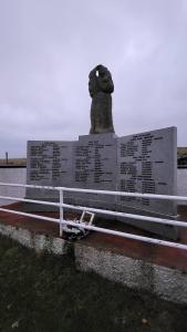

In the eighteenth and nineteenth centuries, Nederton functioned as a Haaf (meaning deep water) fishing station. This type of fishing, financed by Lairds and merchants, used sixareens: a six-person, clinker-built, open fishing boat with a mast, sail, and oars. During the summer months, crews would row and sail their craft out into the Atlantic to set long lines of baited hooks to catch Ling, Tusker, and Haddock. Although sixareens were sea-worthy, and the crews skilled, this type of fishing was very dangerous. In July 1881, 26 boats with their crews of six men set off from Nederton to the fishing grounds in the Atlantic. A terrible storm unexpectedly blew up, and six crews were lost, along with four others from other stations (from Haroldswick, Fethaland, and Ronas Voe). In total, 58 men lost their lives.
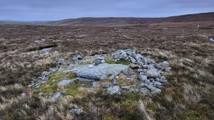
From Nederton Murray and I headed east on a single-track road, walking briskly to reach the shop at Cullivoe and resupply. About a mile east of Nederton, on the south side of the road, we stopped at an interesting archaeological site called Steelnahellenagro. I learned of this site from an article in The New Shetlander, No 298, Simmer 2022, Steelnahellenagro and Skuldigert: rough justice in medieval Shetland, by Danny Jamieson and Brian Smith. This part of Yell was another Herra, a place where justice was administered in the early Norse period. The site comprises a large flat rock, with a scattering of small stones on and around it. Steelnaheelenagro means the spike at the grey stone, and at one time, it is thought, a spike protruded from the ground at this site, where the heads of decapitated criminals and wrongdoers would be displayed. The stane may have functioned like a court, where misdeeds were heard, guilt declared, and punishment administered. Interestingly, 400m away, there is another site, an old enclosure by a burn called Skuldigert, which may derive from the Shetland verb to skuld, meaning to examine a legal case. Oral history accounts, from Yell, tell of how the complainant and accused would race to Skildigert burn, and whosoever reached it first would have the case settled in their favour. The authors of the New Shetlander article propose that the Skuldigert site was where the process of skulding terminated.
After taking photos at the site, we set off again and within the hour we arrived Cullivoe shop. We treated ourselves: coffee, crisps, Coke, and chocolate. After our break, we followed the road south, past Gutcher, to the end of the minor road at North Sandwick. We followed a series of stiles down to Sandwick beach and along to Sandwick broch for lunch. The broch is impressive, with three m high walls and a commanding outlook across to Unst and Fetlar.
Whilst having lunch, I caught a glimpse of something moving amongst the seaweed. Birdwatchers have a term – giss – to describe an overall impression of a species, arising from its shape and movement, from which even a fleeting glimpse can be identified. The giss of an otter is a slithering, almost serpentine movement in the water, quite unlike the movement of a seal. Then we heard a squeaking noise, the tell-tale sign that we had otter cubs. We sat still and watched, and to our delight, four otters came into view, a mum and three cubs.
For the first time on the trip, I was cold. Standing still, engrossed in our otter sighting, the cold had crept in, for Murray too. So far on the trek, I had made do with a cotton T-shirt, a paramo jacket, and paramo trousers. Likewise, Murray was wearing a paramo top and bottom. Paramo is an excellent choice for a multi-day journey in damp, cool conditions, mainly because the fabric dries well. Even in a tent, after a day of drizzly wet weather, one’s body heat will dry the garments. On went my Icelandic jumper, neck buff, and gloves and, after some brisk walking, I was warm.
Another road section led to the head of Basta Voe. The last part of our day involved a 3km path section to the hamlet of Basta, then 3km off-path to Kaywick. From Basta, we walked up the Hill of Basta, past Sigla Water, through numerous peat hags, before descending to Mid-Yell voe, and our camp. We’d covered 31km in eight hours.
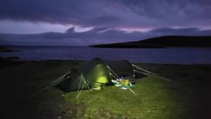
Upon reaching camp, we followed our normal routine: we’d erect the outer tent first, get inside, and use the space to cook some soup and noodles and dry off a bit. After that, we’d erect the inner tent and take turns cooking some more in the large porch. We used one of Murray’s tents, a Fjallraven Abisko.
Late afternoon, as we were eating and warming up, we heard a quad bike. “Are you all right there?” said a voice. A farmer had come to check on us. Apparently, the farmer’s father-in-law had seen our head torches from across the voe and wondered if someone was in trouble. We explained what we were up to and he couldn’t have been nicer, taking an interest in our journey and offering to get us anything we may need, including a dram of whisky.
The forecast for day four was poor: cold temperatures, heavy rain, and 40mph winds. Our goal was to cover 25km and camp at Burravoe. That would leave an easy 8km to go on the morning of day five, time to catch the ferry to the mainland, spend some time with my cousins in Weisdale, and catch the evening ferry to Aberdeen.
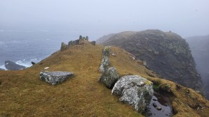
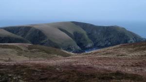
Two hours of road walking brought us to the Mid Yell shop. We bought more food for our last night in camp and set off towards the Hill of Lussetter. Once over the hill, we journeyed around the coast from Vatsetter to Aywick. The coastline along this stretch was again really interesting with sea stacks, deep geos, and two more Birriers.
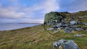
The second Birrer was a fort, with three large defensive walls, 3m high, affording extra protection to the inhabitants who sheltered there. The image below is a reconstruction of what it may have looked like 1200 years ago. To my knowledge, the fort hasn’t been dug by archaeologists.
Once on the road at Aywick, we marched briskly on to Otterswick, Swarister, and then Gossaabrough. Thankfully, the heavy rain had held off til then, but we could sense it was on its way. The last part of our journey took us past a dramatic headland called the Horse of Burravoe, its shape reminiscent of a recumbent horse. By the time we’d reached it, it had begun to rain heavily. It was cold, unpleasant conditions.
In the fading light, we managed to find a ruin to camp inside. The wind had really picked up, and we were cold and wet. The ruin was just big enough for our tent, and its walls provided ample shelter from the wind. Day four was complete, and another 25km was done.
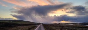
Day five was cold and bright. We rose early, intending to walk the last remaining 8km and then catch the 10:30 am ferry from Ulsta to Toft on the mainland. It was cold front weather: cold air, large cumulonimbus clouds bringing showers of cold rain, sleet, and hail; good visibility; patches of blue sky; and spells of sunshine.
On our way to the ferry, we passed an information panel about a crashed Catalina seaplane. During the Second World War, Shetland was a base for Catalina and Sunderland seaplanes, tasked with hunting German submarines. The crash site is two miles up the Airsdale Valley. Murray and I would have liked to visit it, but my cousin Natasha was due to pick us up from Toft, and the pull of a warm house, a coffee, and some grub was strong.
Before long, we were at Ulsta ferry terminal and our journey was complete. Murray and I reflected on the circumnavigation of Yell. It had been a tough challenge: the distance, the darkness, the difficult terrain, and the cold and wet weather had tested us. The best adventures are ones with an uncertain outcome, where you test your judgment, resolve, and capability. Murray thought that the island was among the most bleak and barren places he’d been to in Scotland, and I would agree with that. For me, though, that was the big draw, to experience the wild, empty, remote corners of Yell before they are scarred by roads, turbines, and pylons.
As we left Yell and looked over the map for the final time, my attention was drawn to the coastline of Unst, an island I am much more familiar with, one I’ve been visiting since I was a child. There were long stretches of coastline there I hadn’t walked. “How about a circumnavigation of Unst next?” I asked Murray. “Sounds good,” he said, “but maybe in the summer!”.