

Norway offers endless opportunities for hiking and trekking: there’s is a vast network of waymarked trails, thers’s over 500 mountain huts to stay in, the landscape is breathtaking and hiking culture is welcoming and friendly. I’ve long enjoyed cross-country skiing and trekking in Norway, but this year, for the first time, Aspen has run Gold Duke of Edinburgh’s Award expeditions to Norway, to the Jotunheimen mountains. They’ve been a big success, enjoyed by all, so we intend to run more trips in 2027, including a trekking holiday for adults. This blog provides an overview of what to expect from a hiking trip to the Jotunheimen mountains.
If you are interested in a Gold Duke of Edinburgh’s Award expedition in Norway, or a guided trek please get in touch.
Where is it and how to get there?
The Jotunheimen mountains mean “Home of the Giants”. It is a large mountain region about four hours bus journey north-west of Oslo. If you look at a map of Southern Norway you’ll see a long fjord called Sognefjord, running east from the North Sea, deep into the interior of Norway. The Jotunheimen mountains are immediately to the east of this fjord. Jotenheimen covers 3,500 square kilometers, and includes 29 of Norway’s tallest peaks, the biggest being Galdhopiggen at 2,469m high. The mountain range is also characterised by large lakes, glaciers and valleys. If travelling from Oslo, a popular start point, to access the mountains, is Gjendesheim. Gjendesheim is at the east end of Lake Gjende and at the start of a very popular hiking trail called the Bessengen. There is a mountain hut at Gjendesheim and a ferry port, providing access west, into the heart of the mountains. Several busses a day go from Oslo to Gjendesheim, taking about four hours. Check out the NOR-WAY and VY bus companies for more info. A good ‘basecamp’ with lots of accommodation options, visitor information, shops and supermarkets is the village of Beitostolen, about 30min south of Gjendesheim and on the bus route from Oslo to Gjendesheim.

What’s the Landscape Like?
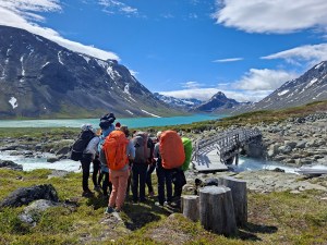
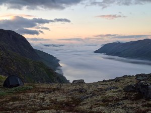
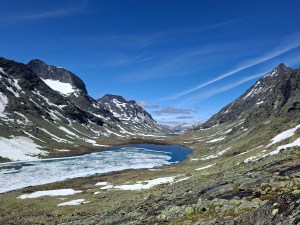
In summary…. amazing. The Jotunheimen mountains has, arguably, some of the best mountain scenery in Europe with glaciers, jagged mountain peaks, beautiful valleys, lakes and woodland. Accessing Jotunheimen from the south east, as one would approach it from Oslo, there are two prominent lakes to take note of: Lake Bygden and Lake Gjende. A seasonal ferry service operates on both of these lakes. The ferries provide access west into the heart of the mountains, providing lots of extra options for your trekking trip. Here’s a sample of the photos I took this year.



Norwegian Mountain Huts
A massive part of the hiking and trekking culture in Norway are the mountain huts. DNT (Den Norske Turistforening) is the Norwegian Trekking Association. DNT manage over 500 mountain huts throughout Norway and maintain summer and winter waymarked trails that link them up. DNT is a membershp organisation, so one gets the best prices and deals if you become a member. Once a member you also get the precious key, that opens up all 500 huts! There are three types of DNT mountain hut: staffed lodges, self-service lodges and no-service cabins.
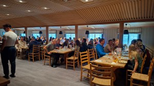
Staffed lodges are like hotels. They don’t have self-catering kitchens, so when you stay there you enjoy a wonderful three course evening meal provided by the hut gaurdians, together with a buffet breakfast, at which you can make yourself a packed lunch. One can stay in a dormitory or a private room. Beds and rooms can be booked in advance. The lodges have comfortable lounges and dining rooms and have a very cozy feel. The food is fantastic and the staff are very friendly and welcoming. The starting price for staying a staffed lodge (if one is a member of DNT) is about 1000 nok. Bring a sleeping bag liner!
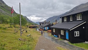


Self-service huts don’t tend to have hut guardians, apart from at the busiest times of the year. Self-service cabins have beds, duvets and pillows; self-service kitchens with stoves, gas, cutlery, and pots and pans; comfortable dining rooms and lounges; stoves; a drying room; dormitories; and, a larder with food you can buy. Beds can be booked through the DNT website. There is a tradition of not turning anyone away from huts, so if one doesn’t book a bed, and a bed isn’t available, there are spare mattresses available for one to sleep on, on the floor. You should bring a sleeping bag liner, because the sheets and pillowcases aren’t changed after each use. The culture of the huts is to do some chores before you leave (e.g. sweeping the floors, wiping down surfaces). Prices for a bed in a self-service hut, for a member, start at around 340 nok.


No-service cabins are much more basic, akin to a Scottish mountain bothy. There are no hut guardians, no larder with food and you should bring a sleeping bag.
If one stays in staffed or self-service lodges, you can travel light. As you don’t need a tent, stove, pots and pans, sleeping bag or mat, carrying a 40 litre rucksack is typical, with warm waterproof clothes and sufficient daytime and evening rations for the days not spent in staffed lodges, where food is provided. This makes multi-day journeys really enjoyable, travelling light and with the scope to do more distance than one would if you were trekking with a tent and being entirely self-sufficient.
When to go?
March, April and early May are the ski season in Norway. DNT mark out winter trails with canes, running through valleys and frozen lakes. Skiers typically use fjellskis, a type of cross-country ski with metal edges and a camber enabling the skier to kick and glide. Skiers typically use grip wax or ski’s with fishscales (a textured base treatment on the middle part of the ski) affording them grip on slopes and making kick and glide much more efficient. With steeper slopes half skins are typically used (a fabric strip with hairs that sticks onto the base of the ski, affording grip). Leather ski boots are typically used with fjellskis. Ski touring kit with full length skins can be used on hut to hut journeys but it isn’t as efficient or fast as fjellskis. When travelling by ski hut to hut during this season, one should always check in advance whether the huts are open, and bring your hut key.
May and June are the transition months, when the temperature increases and the snow melts. During this time the waymarked ski trails are closed down, the frozen lakes become unsafe for skiing and mountain streams become big. Trekking during this time is difficult, because large patches of snow persist, they summer waymarking signs are obscured by the snow and because many of the mountain streams are impassible.
In late June, coinciding with the be start of the school holidays in Norway, seasonal bridges are put in place over many of the mountain streams. There are seasonal, summer bridges and all-season bridges that remain in place all year round. Not all mountain steams have bridges. Expect to get your feet wet at some point crossing wide unbridged streams, or bring some river shoes! The Turkart series of maps show summer bridges with an S and the all-season bridges with an H. By the end of June the number and size of the snow patches will have diminished and the waymarking will mostly all be visible. I recommend taking a snow shovel if travelling and the end of June and early July, to cut steps in slopey snow patches if required. The summer trekking season lasts til September, when autumn snow can be expected. Note that you can get snow in the mountains at any time of the year in Jotunheimen mountains.


What are the Waymarked Trails Like?
The summer trails between mountain huts are marked with a red letter T, painted onto rocks and small cairns. The waymarking is typically about 50-100m apart. Sometimes the paths are very clear, but in other places, at higher altitude and over rocky terrain, there will little or no sign of a path. In foggy weather on rocky terrain the waymarking is really useful to keep on track. The serious nature of trekking in Norway should not be underestimated. The terrain is very rocky; mountain streams and rivers can be hazardous; there can be snow patches with consequential ground below; there terrain can be steep scrambly; it can be cold, windy, wet and snowy; and much of the time you are in very remote country, often with no phone signal. Sticking to the waymarked trails is a good way to mitigate getting lost and straying into dangerous terrain.

Resources for Planning a Multi-day Hike
Here are a list of really useful resources for planning trek:
Norgeskart.no – this web page and mobile map is fantastic for planning a trek and use whilst walking. If one uses the mobile Norgeskart app there is GPS location functionality, to pin-point your location. One can zoom in and see contour features on the base map. All the huts, winter trails and summer waymarked trails are shown on it as well.
DNT – The DNT website and mobile app can be used to research and book and pay for stays in mountain huts. Food purchased in the self-service lodges can be bought through the mobile app as well.
Ut.no – This is the interactive map based resource that is linked to the DNT website. It shows the location of the huts and summer and winter trails. It shows the distances between huts with route descriptions. The base map shows contour information.
Turkart maps – Turkart maps are topographic hiking maps for Norway published by Nordecca. Some parts of Norway are mapped at 1:100,000 and others at 1:50,000. The show huts, roads, paths, summer and winter waymarked trails, summer and all-season bridges and much more. The distance in hours, between huts, is shown on the maps too. Note however that the time estimates are on the fast side. This summer I trekked with a group from Fondsbu to Olafsbu, a distance of 13.5km with 800m ascent, on very rocky ground, laden down with heavy expedition bags (tents etc). The time on the map was shown as 5.5 hours. We took 9 hours! Turkart maps are available from Stanfords map shop in London.
Calazo maps – Another map publisher is Calazo Forlag.AB. These are also topographic maps, available through Stanfords in London.

What to bring?
If you intend to stay in huts, I’d recommend a 40 litre rucksack with the following kit and equipment:
- 40 litre rucksack with rucksack liner (plastic bag) and rucksack cover
- Study walking boots
- river shoes
- Waterproof trousers and jacket
- Hat, gloves, mitts, neck gaiter/buff
- Warm layers (jumpers, fleece, down jacket)
- Emergency shelter (bothy bag)
- First aid kit
- Torch
- Phone, GPS and emergency beacon (for raising help if you have no phone signal)
- Map, compass and map case
- Water bottle(s)
- Food rations
- Walking pole(s)
- Shovel for cutting steps in snow patches (particularly for late June, early July)
- Sleeping bag liner for use in the huts
- Toiletries
- The DNT key and membership info
- Optional – thermos flask, stove for making hot drinks on the trail, sit pad, hut slippers, spare clothes for huts
IMPORTANT NOTE – If you intend to journey hut to hut you are committed to getting to the end of the day’s walk to the shelter afforded by the hut. Bad weather and injury can of course affect your plans and mean you may not get to your intended hut. It is essential that anticipate this and take appropriate spare clothing and some sort of emergency shelter; as noted above a bothy bag, in the event of being benighted on the trail. A twisted knee or ankle arising from the very rough terrain is a very real prospect. Come prepared with a mobile phone and a device for raising help if you don’t have phone signal (an emergency beacon). Call 112 for emergency services in Norway.
Flora and Fauna
In terms of fauna perhaps the most exciting thing to see are reindeer!. They like to inhabit high rocky plateaus, surviving of lichen. By the way, reindeed really do prance!
Other cool fauna seen this year have been birds like Fieldfare, Ring Ouzel and Bluethroat.
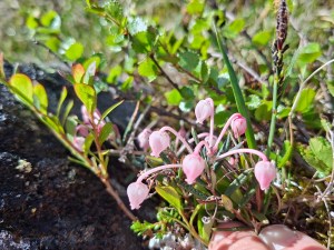
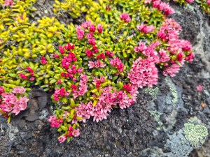
The mountain vegetation is really interesting in Norway. At about 1000m you are typically in a woodland zone with lots of birch and willow, then higher up this gives way to dwarf species like dwarf willow, dwarf birch and juniper. Higher still the terrain becomes very rocky with least willow and lots of lichens. The best time to see wildflowers is late June and July. The array of flowers are fantastic; for example: pasque flowers, purple saxifrage, crimson lousewort, bog rosemary, glacier buttercups and trailing azalea.



To find out more about trips to Norway with Aspen, please get in touch.